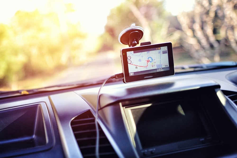
Despite the popularity of smartphone apps, people still buy car GPS systems because smartphone apps come with two major issues: data connection and data collection. The former is subject to network coverage (good luck trying to navigate around a forest) and the latter to privacy issues (have you been keeping up with the news lately?).
Also, GPS units don’t have any annoying interruptions from texts, have a better interface and more detailed maps, among many other things.
If you’re on a tight budget (as many of us are), you may be worried you can’t get a GPS system that will meet your needs. But put your mind at ease – there are many fantastic GPS systems you can get for less than $100.
Contents
- Factors to Consider When Choosing the Best Car GPS Systems
- Best Cheap Car GPS Systems Under $100
- 1. Best Overall GPS: Garmin Drive 61
- 2. Easiest to Mount: TomTom Via 1525M
- 3. Best Premium GPS: Garmin Drive 52
- 4. Best Budget GPS: Garmin Drive 50 LMT
- 5. Best Smartphone Integration: Garmin DriveSmart 50 LMT
- 6. Most Impressive Screen: LTTRBX GPS Navigation for Car
- 7. Best for Truckers: OHREX Truck GPS Navigator
Factors to Consider When Choosing the Best Car GPS Systems
The core concept behind a car GPS is this: a navigation system making use of satellite imagery to provide an illustrated route to the driver requesting one. There are (at the time of writing this article) 31 GPS satellites orbiting Earth working in tandem to relay signals to your device.
The quality of a GPS system depends on how well it interprets and displays this information, as well as the criteria listed below.
Display
The screen size and resolution should be good enough for a glance or two, while driving, to let you understand what is displayed on the screen. On average, you’ll want a screen sized between 5 or 6 inches – large enough to see easily but small enough to not obstruct the road.
Of course, the main point of a GPS is to get you where you want to go. Text-to-speech directions, customizable routes, and automatic recalculation abilities can help you on your way.
While driving, getting heads-ups of potential issues makes your commute much more convenient and saves you a lot of time. Some of these real-time updates to look for include:
- Traffic Reports: Notifications about longer commute time due to traffic jams/ construction work/etc.
- Lane assistance: Lets you know what lane to switch to for upcoming turns and exits.
- Turn-by-turn directions: Audial and visual prompts let you know when and where to make a turn.
Mapping Software
The mapping software depends on the following:
- Areas covered: All the GPS units featured in this list have maps that cover everything from the lower 48 to Canada to all of North America.
- Points-Of-Interest features: Locations and services such as gas stations, cafes, watering holes, and grocery stores, among many other things.
- Lifetime map updates: This feature keeps the map routes and details up to date indefinitely. It also adds new roads and destinations to your GPS database, while also fixing errors in street names, traffic directions, and points of interest.
Additional Features
Some extras can help make your commute easier, such as Bluetooth, WiFi and voice command.
For even more tips on what makes a great GPS system, check out our more thorough guide below.
Now that you know what to look for, let’s dive into the 7 best GPS systems under $100.
Note: Some of these products are refurbished but the quality is as good as new (you wouldn’t know if you weren’t told ahead of time). If you’re skeptical, all of these products are covered by various warranty policies, so you can feel safe trying them out.
Best Cheap Car GPS Systems Under $100
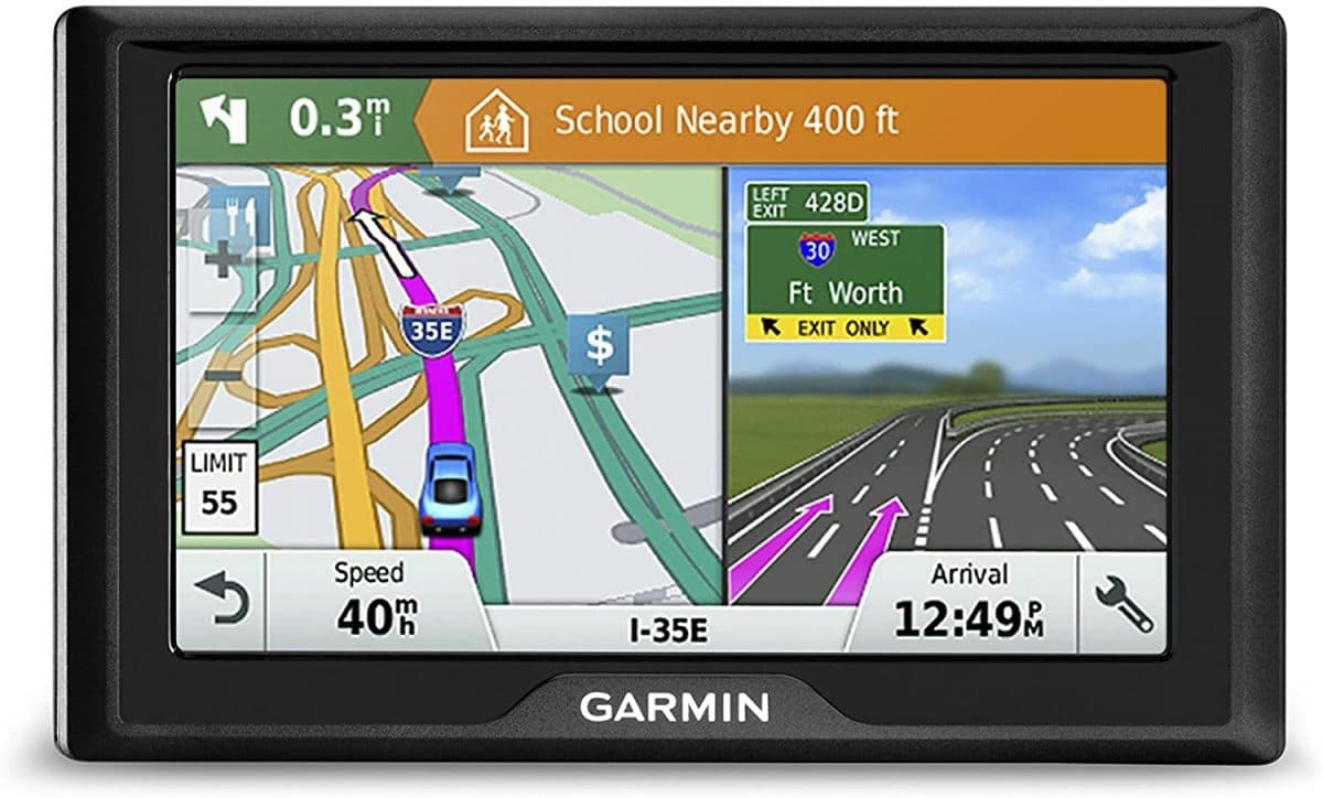
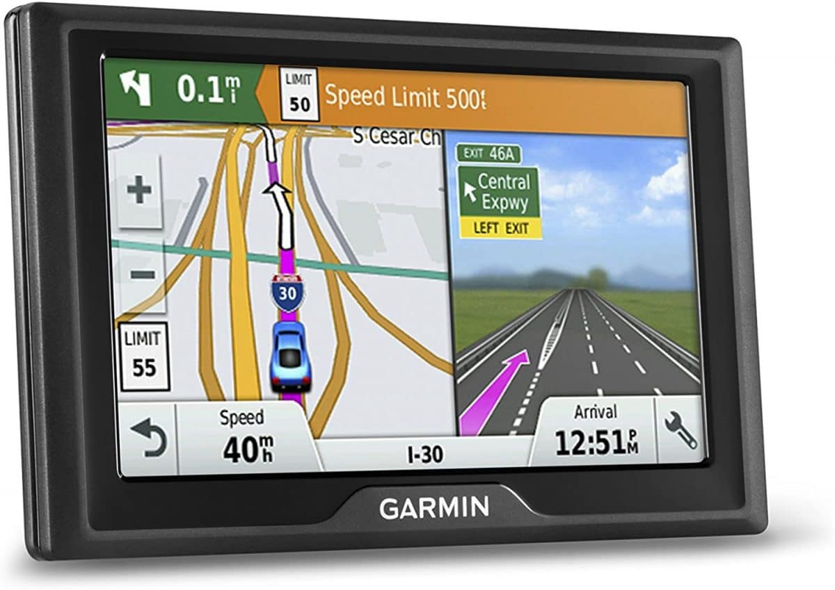
1. Best Overall GPS: Garmin Drive 61
Editor’s Rating:
Type: Refurbished*
Display
The Garmin Drive 61 features a touchscreen measuring 6.1” diagonally with a resolution of 800 x 480 pixels, on a dual-orientation, color TFT LCD. The result is a very, very fine-looking screen. It can be viewed either in landscape or portrait orientation.
Navigational Features
The programming behind the Drive products makes the text-to-speech directions sound less like they’re coming from navigation devices and more like a bunch of friends you’re dropping off in an area they know very well. You get a, “Turn right at Allegheny Avenue,” instead of an, “In 300 yards, turn right,” courtesy of the Real Directions feature.
You also get lane assistance – a godsend when driving in an unfamiliar area. For example, the GPS unit says, “In 520 feet, be in either of the two right lanes, then turn right at the stoplight.” Instead of a much more ambiguous, “Turn right in 520 feet,” in a monotonous tone that’s typical of many GPS units.
You can choose a customized route based on how you want to get where you’re going, with the help of features such as the Route Avoidance. The Direct Access feature simplifies navigation by suggesting a less-crowded place within a destination that is a crowded area, such as a shopping mall.
However, you do not get real-time traffic updates, which can be a bummer in cities with lots of traffic (looking at you, L.A.). If that’s important to you, consider the Garmin DriveSmart 50 LMT.
Map Features
The Drive 61 comes with a vast array of detailed maps for the lower 49 states and Canadian roads (for the latter, you’ll have to pay slightly extra). These can be updated for up to 4 times a year at no cost. You can choose to view the map from a single 3D map view or double 2D map views.
A ridiculously extensive list of POIs is present within the database of the Drive 61, courtesy of Foursquare. These POIs come with ratings and reviews by other people on everything from hotels to bodegas to watering holes to cafes on your route via TripAdvisor. You can also add your own customized POIs.
- Large Screen
- Great Resolution
- Lifetime Map Updates
- Garmin Real Directions Landmark Guidance
- Lane assist with junction view (displays junction signs)
- No voice command
- No real-time traffic updates
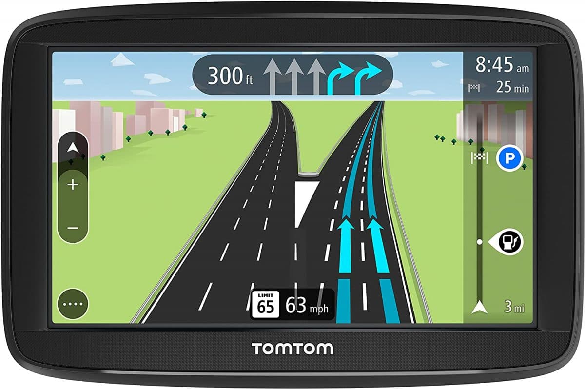
2. Easiest to Mount: TomTom Via 1525M
Editor’s Rating:
Type: New
Display
The TomTom Via 1525M features a 5” screen with a brilliant display, boasting a resolution of 800 x 480 pixels with an anti-glare coating. That being said, the touchscreen is slow to react, and you’ll find yourself having to type each letter twice sometimes.
Navigational Features
The TomTom Via 1525M also features text-to-speech directions, albeit not with the personalized tone from the Garmin Drive Series, like in the Garmin Drive 61.
Akin to the “Lane Assistance” feature in the Garmin GPS units, the TomTom Via 1525M features Advanced Lane Guidance that utilizes split-screen lane guidance to relay directions with much better clarity.
However, the device features no traffic updates.
Map Features
The Via comes with loaded maps for all of North America, including all 50 states of the US and Canada and Mexico. You can download additional maps/upgrades on the 1525M through MyDriveConnect on your computer. That being said, it takes an obnoxiously long amount of time for each upgrade (at least 3 hours).
The map database also comes with millions of POIs, typical of all quality GPS systems.
Additional Features
One of the best parts about the Via 1525M is the mount. The suction cup is very easy to use – all you have to do is rotate the cup base a little while placed on a flat, smooth surface, and it sticks instantly. Conversely, you can remove the suction cup by rotating the base in a counter-clockwise direction. It stays firmly stuck for a long time, regardless of the temperature.
- Incredibly easy to mount and dismount the device
- Advanced Lane Guidance
- MyDrive Connect
- Slow touch screen
- Downloading and upgrading map features takes too long
3. Best Premium GPS: Garmin Drive 52
Editor’s Rating:
Type: Refurbished*
Display
The Garmin DriveSmart 52 features a 5’0” touchscreen with a resolution of 480 x 272 pixels, with 2D and 3D views. Not exactly “watching Avatar at an IMAX theater” quality, but it does pretty well for a basic GPS. It also features day and night modes. If you’re looking for an outstanding screen, you may prefer the LTTRBX GPS Navigation for Car.
Navigational Features
The Drive 52 comes with multiple premium navigation features. It allows you to set your own customized routes based on how long, how much, and what you want to see when you ride. Text-to-speech offers directions in a manner that’s very easy to understand, from Garmin Real Directions. It provides automatic recalculation of your routes for you ahead of time, if there are traffic delays.
Its lane assist features a realistic illustration of an upcoming junction with brightly colored arrows showing the way. And speed limit indicators, and alerts for sharp curves, school zones, red lights and speed cameras help keep you safe.
Map Features
The Drive 52 comes with detailed preloaded maps of all 50 states of the US and Canada that you can view in both 2D and 3D. The maps also receives free updates (up to 4 times a year) over the lifetime of the GPS unit.
One of the best parts about the Drive 52 is the database featuring points-of-interest from the History Channel and the National Park Directory, in addition to those already present in Foursquare.
The former features pictures and descriptions of historical monuments, parks, historic sites, and museums while the latter features turn-by-turn directions to national parks, including information and directions to campgrounds, visitor centers, picnic areas, and trailheads. But be careful if you’re heading something extremely balmly, since it can overheat in particularly hot weather.
- Lifetime Map Updates
- Garmin Real Directions Landmark Guidance
- Lane assist with junction view (displays junction signs)
- An exhaustive database of the best national parks and historic sites in the country
- Possibility of overheating in hot weather
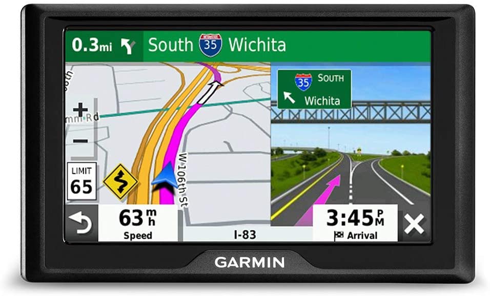
4. Best Budget GPS: Garmin Drive 50 LMT
Editor’s Rating:
Type: Refurbished*
Display
The screen display of the Drive 50 LMT features a color TFT touchscreen with a 5” screen size and a resolution of 480 x 272 pixels. The screen can be viewed either in landscape mode or in portrait mode. You get to view the device in both 2D and 3D views.
Navigational Features
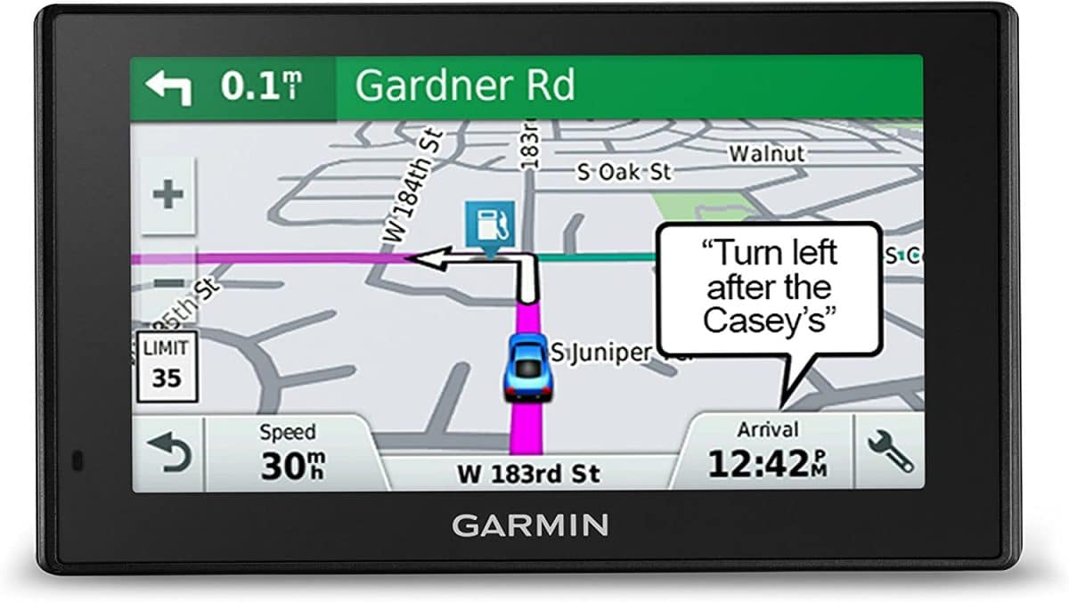
Courtesy of the Garmin Traffic, this GPS provides you with real-time traffic reports every 5 minutes, from the information provided by the traffic-RDS by NAVTEQ, a geographic information system provider that is now owned by Nokia. Real Directions Landmark Guidance keeps you on track. There are detailed preloaded maps (for this model, all roads in the US) with more than adequate detail for the average user. And alerts for upcoming areas such as school zones, rail crossing and animal crossings ahead of time keep you prepared.
Lane assistance and speed limit indicator for most American roads are especially welcome features in a budget model. Plus, you can plan a trip with multiple destinations and rest stops with Trip Planner. You can have the device do the normal route calculation between all the interim destinations, or you can manually set your preference for the route in between.
Map Features
The Garmin Drive 50 US comes with preloaded maps for all lower- 49 American roads, which can be viewed in both 2D and 3D. The Direct Access feature helps you find your way to specific points at select malls, airports, and universities.
There is a database with millions of POIs that encapsulates everything from hotels to watering holes to movie theaters and is constantly updated by Foursquare.
Free lifetime map updates (of the maps already preloaded) for download up to 4 times a year make sure you’re always up to date.
- Lifetime map updates
- Garmin Real Directions Landmark Guidance
- TripAdvisor traveler ratings
- Route shaping through preferred cities/streets
- Lane assist with junction view (displays junction signs)
- Driver alerts for sharp curves, school zones, red light, and speed camera warnings and more
- No voice command.
- You can only update maps by hooking the GPS up to a computer with a Garmin Express application.
5. Best Smartphone Integration: Garmin DriveSmart 50 LMT
Editor’s Rating:
Type: Refurbished*
Display
The Garmin DriveSmart 50 features a 5” TFT touchscreen with a resolution of 480 x 272 pixels and white backlight. The resistive touchscreen can be viewed either horizontally or vertically and features a pinch-to-zoom display.
Navigational Features
The DriveSmart 50 LMT is a fusion of the best features of the Drive series and some of the most important functions of your smartphone.
From the Drive series, it has the following features: Real Directions Landmark Guidance, alerts for caution areas such as school zones and rail crossings, lane assistance, live traffic updates, automatic recalculation of your routes ahead of time (which can be slow at times), and a speed limit indicator.
Map Features
The DriveSmart 50 LMT comes with preloaded maps (with exhaustive detail) for the USA, Canada, and Mexico. These maps can be viewed in both 2D and 3D. Like other Drive units, it comes with lifetime map updates too.
It also has a search field that retrieves all relevant POIs with the assistance of Foursquare. The Direct Access feature also provides door-to-door directions to destinations within select malls, airports, and universities.
Additional Features
The defining characteristic of the Drive Smart series is the ability to pair your GPS unit with your smartphone over Bluetooth (through the Garmin Smartphone Link app for iPhone and Android). This makes your GPS incredibly convenient to use, by letting you do the following:
- Voice-activated navigation: You can operate your GPS unit for the entirety of your trip with your hands on the wheel. Just say “voice command” to activate it.
- You can answer incoming calls and texts and tend to on-screen calendar reminders and app updates.
The inclusion of built-in WiFi also means you get automatic map updates every time you’re near a WiFi network, as opposed to having to hook it up to a computer every time.
- All the environmental awareness features present in the Drive series
- Voice-activated navigation
- Bluetooth pairing
- Answering on-screen texts and calls
- Automatic map updates
- If not adjusted with settings, the notifications from your smartphone will interfere with the screen
- Rerouting can be slow
Editor’s Rating:
Type: New
Display
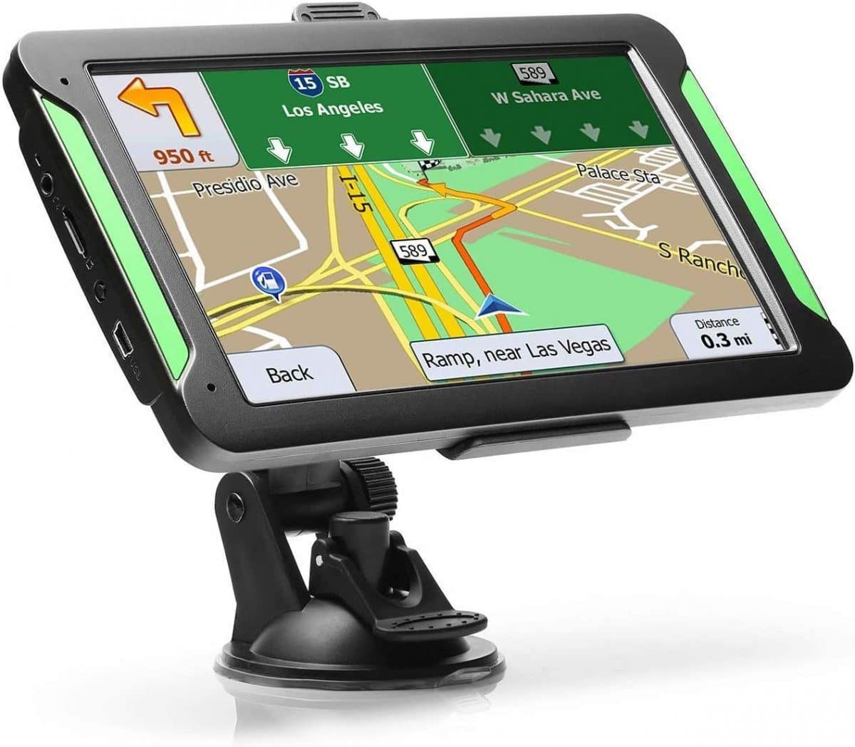
The size of this GPS is going to make you do a double-take. Although the 7” display makes the LTTRBX seem like a tablet masquerading as a GPS unit, it’s not. The TFT touchscreen also has a resolution of 800 x 480 pixels, and the perfect combination of size and clarity results in a brilliant display.
Navigational Features
Alert for upcoming areas such as school zones, rail crossing and animal crossings ahead of time make sure you’re never caught off guard. As do the other units on this list, the LTTRBX comes with text-to-speech directions. However, the timing for these directions when relayed is sometimes inappropriate and often inconsistent (you may get a “turn left” prompt at a distance anywhere from 100 feet to a half-mile before you have to turn left).
There is a pseudo lane assistance feature present in the form of a multi-lane highway that can, however, be confusing at times. A speed limit indicator helps keep you safe.
The routes the GPS calculates for you are generally correct, but sometimes you may find yourself given directions to take unnecessarily longer routes or driving on roads that aren’t exactly fun to drive on despite having a highway to your destination.
Map Features
The LTTRBX comes with preloaded maps for 101 regions covering almost all of commutable North America.
Map updates for the LTTRBX can be availed by email request once-a-year, which is infrequent. The fact that the LTTRBX doesn’t have an online guide doesn’t help you either. However, there is a lot of map clarity and the street names and directions are generally accurate.
It also has a database containing millions of POIs, postal code and street names.
- The largest screen on this list
- Brilliant display
- Cheapest GPS on this list
- Turn signals and directions are not notified ahead of time
- Poor customer support
- Not user friendly
Editor’s Rating:
Type: New
Display
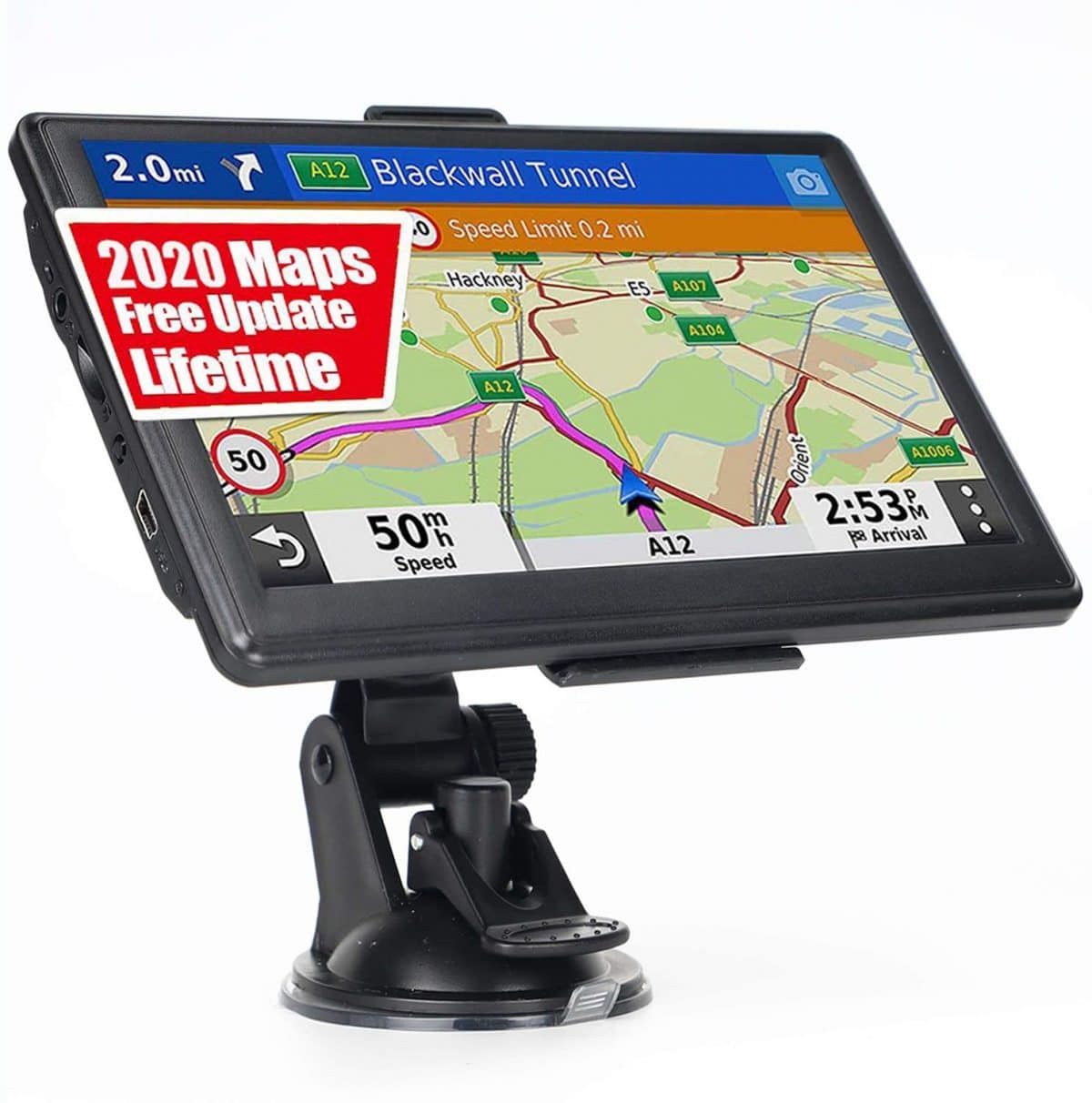
The screen size of the OHREX GPS is 7 inches with a resolution of 800 x 480 pixels, making for a really fine display, on par with the LTTRBX GPS.
Navigational Features
Turn-by-turn directions and street names are broadcast through the speaker, as well as
driver alerts to let you know about upcoming danger zones. It’s lane assist feature lets you know what lanes to merge into ahead of time.
It also plans your route to save the most time, and it offers a speed camera detection feature. However, the GPS does not feature any traffic updates, and many times, the directions relayed are wrong.
Map Features
The OHREX GPS features comprehensive maps of the USA and other countries that you can receive free downloads of via e-mail. The database also contains a gigantic list of postcodes, addresses, and coordinates, in addition to points-of-interest.
However, you cannot use a Mac computer to operate maps update, as the system is only compatible with Windows.
- Suited for larger vehicles such as RVs and trucks
- Large, beautiful display
- Cannot update maps if you have a MacBook
- No traffic updates
- Routes calculated are sometimes unnecessarily long